Saturday 24 May 2014

Union Alley

Look at any historic reference to South Shields town centre and you'll probably find mention of Union Alley. Once the home of many public houses, including over the years the Black and Grey, Golden Lion and City of Durham as well as eating establishments such as Curry's Silver Gill.

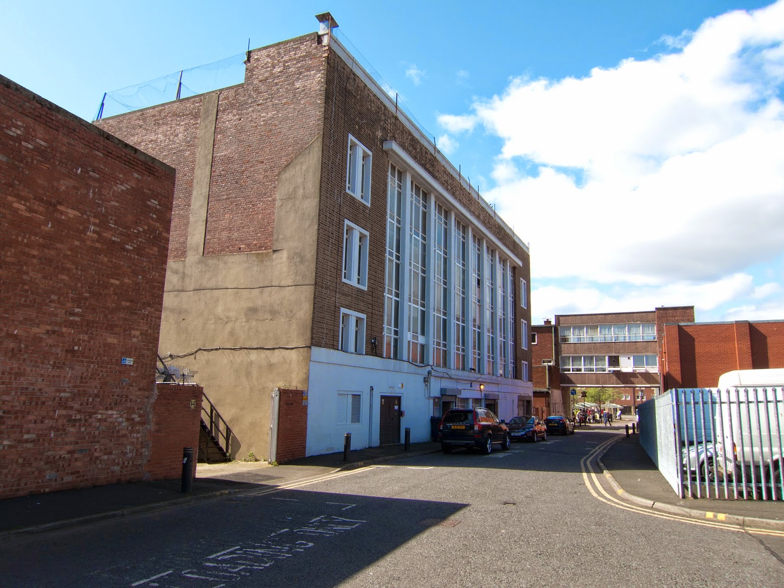
Now little more that a lane to the back of a few buildings on King Street and a huge bleak wall forming part of Wilkinsons in the Market lace, this little Alley has none of its former character.


There is now only one way into Union Alley, that is from the Market Place itself under the flat arch created by the what is now the Market View Restaurant abutting what used to be the City of Durham pub. The City of Durham closed in 2005 and is now Alderman's Coffee House. The low single story building which is the side of the coffee shop still has the look of a public house about it.


Next along is the back of what was Woolworth's. This building was built after the war and opened on 21st August 1950 after the original Woolworth's building on King Street was destroyed during the bombing of the town centre on 2nd October 1941.


At the very end of the Alley on the Southern side is the back of another of the great but now alas closed King Street shops, Marks and Spencer. Another sad demise, opened in 1934 and surviving the blitz, the shop finally succumbed to the recession and "corporate streamlining" and closed it's doors in March 2014. The building, now with Grade II listed status was once the "New Theatre".


At the far Eastern end of the Alley and looking back towards the Market Place we can see that the Northern side is now nothing more than a storage area and carpark for the Market Traders and the side wall of Wilkinson's shop.


Tuesday 8 April 2014

The Market Square

The Market Place in South Shields has been the hub of the town throughout the ages with the Old Town Hall at its centre. This was built circa 1767 by the Dean and Chapter of Durham and the open ground floor used as a market hall. It is now Grade I listed and was restored in 1977 after years of neglect.

The Market Place was bombed extensively during 1941 demolishing many of the buildings. However the Old Town Hall and St Hilda's remained.

Looking South to Saint Hilda's Church


Looking North-West.


Here we have panoramic shots of the Market Place looking North. The first taken in March 2013 before Wouldhave House was demolished and the second taken August 2013 afterwards.


Similarly looking West we can see how the demolition of Wouldhave House  has dramatically opened up the Market Square, albeit temporarily, giving views across the River.


Looking directly North.


The old buildings on the Eastern side of the Market Square were demolished during the air raids of 1941 and were replaced by the white stone, contemporary looking buildings we have today.


Running from this Eastern side are three parallel roads. The most Northerly is Union Alley, starting underneath the square archway in the corner of the Market Square.


Then we have King Street. Once the main shopping street in the town but sadly now becoming more rundown as more of the big name shops leave (Marks and Spencers closed down in March 2014), and other developments take off such as the new buildings housing BHS, Debenhams, Next and River Island just off Kepple Street.


The third street is Chapter Row, running from the Southen edge of the Market Square from just in front of St Hilda's until it turns into Kepple Street a few hundred yards further East.


St. Hilda's church is build on the site of a much earlier chapel built by King Oswy of Northumberland at the request of St Aiden in around 647AD. This chapel was supposedly placed in the care of St Hilda (or Hild of Whitby) and I've seen various references to it being either a monastry or a nunnery. Neither of which I know which is correct. The original chapel was sacked by the Vikings in 865AD and it wasn't until 1100Ad that the Normans built a church on the site.

The Norman church is mentioned in a charter of 1154AD and has a further mention in a charter of King John in 1204. This original church was rebuilt in 1700 and the current church was also damaged in the 1941 air-raids when it lots some of its memorial windows.


Although the churchyard has in the most now been landscaped, at the Southern side of St Hilda's you can still see some of the old gravestones against the wall of the building. I'm sure as a child I can remember many more and the churchyard looking like a proper graveyard.

Sunday 31 March 2013

Between the Market and the River


After the charismatic buildings of the Mill Dam we amble towards the area between the River and the Market Square and a particularly uninspiring part of the town. Although this area is now part of a prime redevelopment plan with the whole waterfront undergoing a major regeneration over the next few years, the first of the new buildings in this ares just leaves me cold. The BT building is to me neither in keeping with the area's past or particularly complimentary to what I would hope the future would be.


In contrast on the opposite side of the road on the side of a 1960s building Wouldhave House, forming part of the Market Square is a mural depicting the a lifeboat. The lifeboat is synonomous withe the town, William Wouldhave the inventor of the self righting lifeboat being from South Shields and of course the lifeboat being the symbol of the town before South Shields became subsumed into South Tyneside. This local landmark although pilloried by the locals when it was first painted in 1981 by David Wilkinson and repainted in 2000 by street sign writer Gavin Buckinham is now a well-loved landmark due to be lost mid 2013 when the building it is on is pulled down as part of the redevelopment.

It is said that when it was repainted to recapture the original faces which had faded the artist used Alan Shearer as the inspiration for the figure on the far left of the boat.


Walking North along Ferry Street I remember this area of the town feeling particularly dark and univiting when I was a child. Now at least it is open and the new apartment block if not particularly pretty doesn't jar the senses too much.

Between the apartment block and Wouldhave house is a strange green arch which I think is meant to lead invitingly from the Ferry landing to the Market Place. I'm afraid I really can't comment except to hope that this too is due to be redeveloped. 

To the North of the apartment block and we get a glimpse of the back of the Western side of the Market place, all soon to be demolished.


Across the road toward the river is the Alum Ale House, the only public house now surviving in this area of the riverside and the oldest licenced premises in South Shields with some parts of it dating back to the 17th Century. The Alum Ale House stands on what was once Alum Ham, a public landing place where fare paying passengers would pay the scullermen to row them across the Tyne. 

 Today there is no need to be rowed across the Tyne with a public passenger Ferry running regularly from South Shields to North Shields. There have been numerous ferries over the years. I can remember the Freda Cunningham and I'm told by my parents that a car ferry used to run before the advent of the Tyne Tunnel. Today there are two ferries in operation, The Pride of the Tyne (1993) and the Spirit of the Tyne (2007) capable of carrying 303 and 200 passengers respectively. Both twin diesel vessels, the design of the Pride of the Tyne was based on the Shieldsman ferry, whilst the Spirit of the Tyne was based on the Gosport ferry running between Portsmouth and Gosport.

The Ferry Landing at South Shields was built in 1999 to replace the century old ferry landing that was previously used. The new landing has 3 berths and an indoor waiting area.


Looking down stream from the ferry landing we have the new development at Broad Chare. These multi-coloured houses are built on the site of the old Tyne Dock Engineering, or TDE as it was known. The development incorporates the old docks one of which is full of water and still sends shivers down my spine when I see its murky green expanse.

So we end this part of the walk which will change dramatically over the next few years.

Sunday 24 March 2013

Customs House and Mill Dam

We start our pictorial ramble in the Mill Dam Conservation Area, which takes its name from a 13th Century mill owned by the Prior and Convent of Durham which once stood here.

Right on the river front is the Customs House. A Grade II listed building which is now a thriving theatre and cinema, the Customs House was first established in 1848 or 1864, resulting in a boom of trade to the town.
Next to the Customs House was the River Police and Sanitory Authority Building, which also housed the morgue. Now converted to apartments many residents probably have no idea of the past use of the building


Dividing the two is Dalton's Lane, running up between the two buildings.

At the back of the River Police building and now joined to the Customs House extension by a glass walkway is Dalton's Lane Workshops. The only remaining example of artisan workshops left in the area.


This is the back view of the River Police building. Bodies pulled from the Tyne would be taken into the Morgue via this back door.


This group of building form part of the Mill Dam conservation area with the old shops now converted into modern apartments bounded on one side by...

Unity Hall...

and on the other by the Mission to Seaman building.
Next to the old, historic buidlings of Customs House and other Mill Dam buildings we have the first of many new buildings in the shape of the BT building providing a backdrop to the last remnants of the former Swinburne Glassworks, the chimney with its date stone proclaiming 1865.


 It was only natural that many public houses would spring up next to the busy port and the road down to the Mill Dam still hosts some of these old establishments; the Steamboat having the most interesting exterior with its carved faces and is a Grade 2 listed building.


Each of the buildings has it's own distinct design, obviously built at different times. The narrow building to the right of the Waterfront pub was once a post-office but now forms part of the Steamboat.
This last building on this side of the Mill Dam is the last of our public houses, the Riverside. 

At the top of the Mill Dam a mural was painted in the 1970s depicting the many facets of Tyne Dock through the ages.
 
On the opposite side of the road to the public houses is a long, high, red-brick wall encompassing the now bricked up openings of Staithes House originally built to provide facilities for Harton Low Staithes' engine drivers and coal handlers.